The Seven Wonders of Takegashima
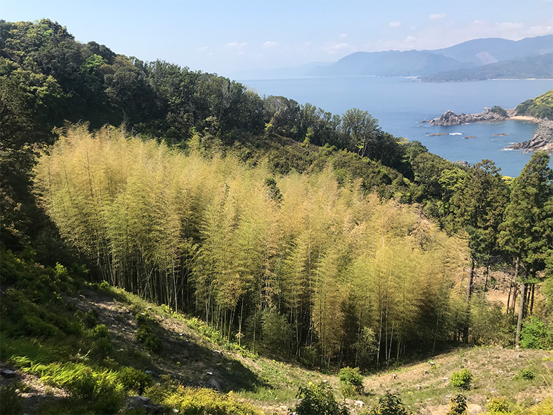
Bamboo grove growing in the center of Takegashima
Takegashima is a hidden holy land located off of Shikoku Prefecture and is a place that is associated with Kobo Daishi. Along the eastern coast of the island stands the majestic and beautiful "Wall of Rock," which cannot be found anywhere else in Japan. The central part of the island is a hollow surrounded by raised rocks from north to south,and in the center is a bamboo grove about 100 meters in diameter. The existence of this bamboo grove, which has grown thickly since ancient times, is the reason why the island is called " Takegashima" or “bamboo island”. A number of puzzling mysteries lurk on Takegashima. By unraveling these mysteries, people are sure to discover why Kukai valued this island so highly. Let’s explore these mysteries at once.
1. Is the bamboo grove on Takegashima man-made?
Takegashima is called the “island of bamboo” due to the bamboo forest growing on the center of the island since ancient times. The size of Takegashima is 600 m from north to south and approximately 400 m from east to west, and the bamboo grove is only about 100 m overall in diameter. In other words, the bamboo grove area is quite small compared to the rest of the island.
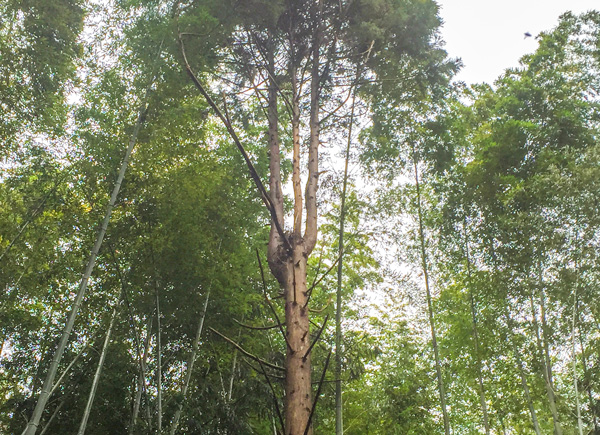
The Three-Branched Sacred Tree
at the Center of the Grove!Takegashima Island is thought to have risen from the ocean from the Shimanto Belt, which is the geological formation and formed from deposits on the seafloor of the continental shelf slope, and there are a number of major fault lines running from north to south of the island. The eastern coast of the island was outcropped by marine erosion and Takegashima Island, which is located between the fault lines, was formed by boulders that were uplifted along the fault lines. Takegashima was formed from major rock uplifted from two major faults, with the center of the island hollowed out between the two faults. This is where the bamboo grove grows. Is it really possible that the bamboo grows naturally in the middle of an uplifted rock island with a shoreline that rises 100 meters above sea level?
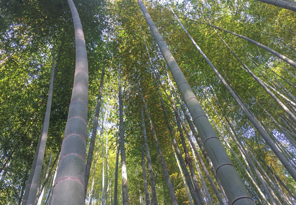
It has been said that bamboo is not an ancient Japanese species, but a plant that originated in China. Therefore, the fact that bamboo grows on Takegashima Island means that this forest is not a product of nature, but rather, it’s possible that ancient people who brought forestation technology from China intentionally planted bamboo in the center of Takegashima. Given the absence of bamboo forests on the outlying islands around Takegashima, there is no reason to deny the credibility of the man-made forest theory.
The Bamboo forest grows only
in the center of the islandThe roots of bamboo trees do not burrow deeply into the ground; rather, they spread out horizontally close to the ground while covering the ground with their hard roots like a mesh. As a result, other plants are usually prevented from growing in areas where bamboo trees are thick, and only bamboo groves grow. Moreover, the extremely hard roots of the bamboo cover the ground and stabilize it so that it does not collapse easily even if it rains downpours. Perhaps the bamboo forests of Takegashima were intentionally planted to strengthen the ground.
Let’s take a closer look
at the bamboo grove
on Takegashima!When we actually look at the ground where the bamboo trees grow, strangely enough, there is a big difference between the ground on the southern slope and the northern slope. The northern slope is also a steep slope just below the top, and it looks as if these gargantuan stones, 1 to 3 meters in diameter, were piled up and covered the surface. In fact, there is a layer of air beneath the stones. For example, when a fire was made in the lower part of the northern slope, smoke came out from the gaps between the stones in the upper part, which is about 10 meters from the fire, suggesting that there are various cavities between the rocks, whether natural or man-made. Also, on the southern slope, as one enters the bamboo grove, crushed rocks are scattered as they were scattered all over the ground. They were not naturally deposited, but it looks like fine granite stone are spread over manually.
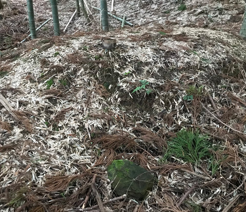
The center of the grove is
raised above the groundAnother reason why the bamboo grove seems to be man-made is because the center of the grove is raised above the ground. The center of the bamboo grove, which grows between huge rocks that were uplifted, is raised to a height of 1 m and a diameter of 5 m.. It looks like a small burial mound. A survey of the ground revealed only a layer of curved rocks about 5 m below the surface, and there is no particular reason why only the upper part of it was raised. It is assumed that it was probably raised by human hands with soil fill and that it served as a kind of ancient ritual site. The presence of a sacred megalithic rock called the "Wall of Rock" on the east coast and the hat-covered summit stone at the top of the island suggest that bamboo was planted in the center of the island, and that this may have served as a place of prayer. Hence, as discussed previously, a seven-tiered terrace may have been built in the direction of that ritual site.
2. Why does a shrine exist on a small remote island like Takegashima?
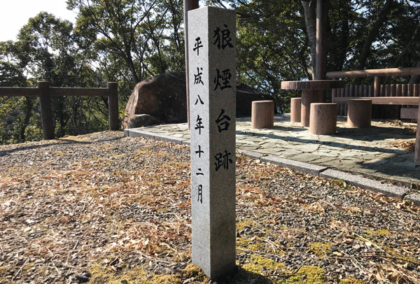
A stone monument at the site
of the Smoke Signa platform
which is located at the
top of Takegashima Island.Currently, Takegashima is connected to the land by a short bridge of about 50m. In ancient times, however, the island remained isolated. A landmark was built on the summit of the island in ancient times that was used as a base point for maritime traffic. It has been known that there were several such smoke signal towers from Takegashima to what is known as modern Tokushima City. Among them, Takegashima was the most southern island of the ones facing the Kii Channel.
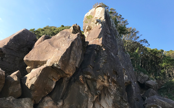
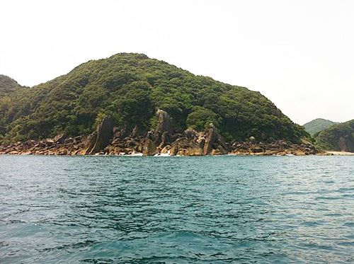
A mammoth megalith
on the eastern shore of the islandA mammoth megalith on the eastern shore of the island and a 30-meter-high wall of rock is where a deity has been enshrined since ancient times. The reason why a deity was enshrined along the eastern shore facing the Pacific Ocean is a mystery even though the island was uninhabited until recently and is not very large. There are no shrines, no torii gates, and no man-made structures of any kind. There are only the lapping waves of the Pacific Ocean and the giant stones towering over the eastern shore of the island.
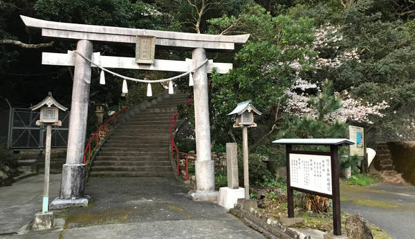
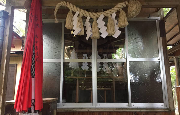
The Torii gate and abbreviated
summary of Takegashima ShrineNo deity is enshrined without a reason. It can only be assumed that they were enshrined for some very important reason that happened in that place back in ancient times. The sacred place on the eastern shore, also called "Urauso," was used as the inner shrine, and in later times, Takegashima Shrine was built in the northern part of the island, which is closer to land. It is precisely because the sacred place of the rock formation was so cherished that it must have contained a tremendously important history and message.
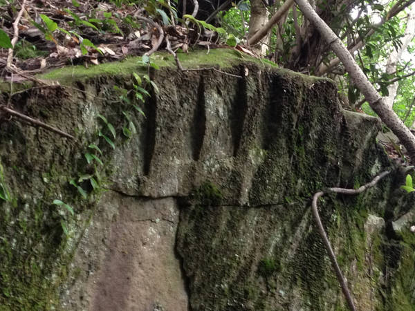
3. Is the rock circle of the Okumiya shrine a natural "Wall of Rock"?
On the eastern shore of Takegashima, there is an especially unusually shaped boulder. It has a thin wall of rock that is about 3 meters wide and 30 meters high. At the top of the "Wall of Rock" is a round boulder, which has been revered since ancient times as the most sacred place.
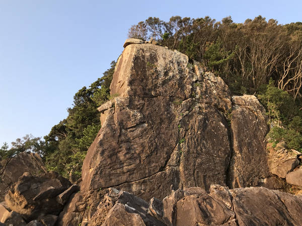
Iwakura towering as a huge wall rockThe peculiarity of this "wall of rock" is that, as it is called a "wall," it has the shape of a wall rising up from the sea surface with a width of approximately 3 m. This means that when the bedrock was uplifted from the ocean, the rocks on both sides collapsed and fell away, forming a thin wall that exists to this day.However, there is no signs that rocks on either side of the wall fell as far as we can see now. The only visible sign is that the front of the wall of rock, the 3-meter-wide front facing the Pacific Ocean, shifted off of the top, leaving an imprint that it has fallen in. Thus, the front of the wall is almost flat. Thus, the "Wall of Rock" became a strangely shaped rock with flat faces on three sides.
Is it even possible that rocks of this shape were formed by natural uplifting and subsequent scouring by sea water and wind? Where did the rocks that were supposed to have fallen away from the wall of rock on either side go? Why was a deity worshiped at the top of the "Wall of Rock"? Are the round-shaped boulders there natural? Or were they brought there by manpower and worshiped there?
The three wall rocks towering on the east coast of TakegashimaThe larger question is that when this "Wall of Rock" is viewed from a distance on the Pacific Ocean, the wall appears to be a trio of neatly placed rocks. This "Wall of Rock" is the largest of the three, and it has remained in its original shape and form up to the present day. The eastern shore of Takegashima is a rocky area consisting of uplifted bedrock, but why do the three walls seem to rise only in the northern part of the island, where this "Wall of Rock" is located? Or did ancient people carve the rock and intentionally make a row of three walls? Why was there a reason for such a construction? The questions are endless.
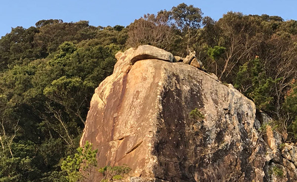
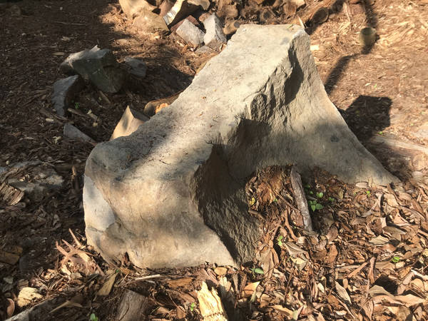
4. Are the megalithic shades seen on the summit stone a product of nature?
Is the curiously shaped summit stone man-made?
The stone at the top of Takegashima is a magnificent shade shape
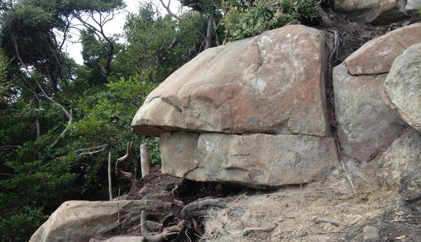
There are several exposed rocks at the top of Takegashima, facing toward the coast. Today, a shaded bench has been set up on the summit as a rest area on Takegashima. Adjacent to it is the summit stone. The shape of the boulders looks like a hat. It looks obvious from the side that the boulder looks as if a shade was placed on top of it. Could this really be a product of nature?
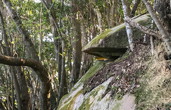
A huge stone near the summit also wears a hat.The top of the island is located along the path of the "Shikoku no Michi" (Shikoku Road). Then, as you walk 50m along Shikoku Road toward the north from the summit, you will see a large boulder over 5 meters in diameter on the right Pacific Ocean side of the path. If you walk straight down from this boulder toward the ocean, you will reach the sanctuary of the "Wall of Rock. In other words, this megalith is the uppermost megalith directly above the "Wall of Rock”. When you look at this megalith from the side, the megalith looks like it’s wearing a hat. The shape of the stone can only be described as mysterious. Was the hat man-made?
Stone CircleUnder this boulder, there are many rocks that lie directly beneath the boulder. After the soil that covered them for many years was removed, the shapes of the rocks buried underneath were revealed. Then, it appeared that the rocks seemed to be arranged in a circle. Did the rocks that were arranged in a circle, like in a stone circle, happen to be exposed in front of the megalith by chance? Or, perhaps the stones that broke off from the megalith fell into a circular line. However, since there appears to be a hole directly below the megalith, we cannot deny that the megaliths were most likely piled up. The “monk hat” on the megaliths, the arrangement of the rocks laid out in a circle, and the fact that the "Wall of Rock" sanctuary is located directly below the megaliths, and face out toward the sea, suggests that some thought was put into the area surrounding the megaliths. I wonder if ancient human hands were involved in creating this area.
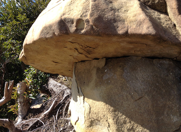
The sacred stone lying at the
top of the Wall of RockThis canopy rock is also in the shape of a hat, i If you walk straight down to the sea from the point where the stone circle and the giant stone hat are located, you will find the "Wall of Rock," the largest rock formation of giant stones on Takegashima. This connection is not just a coincidence. Not only does a huge stone lie at the top of the rock, but the top of the rock also has a stone protruding out into the sea that forms the shape of a hat. Can we really say that this too is a product of nature?
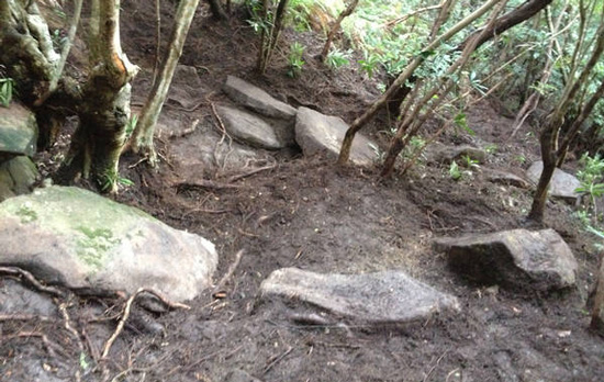
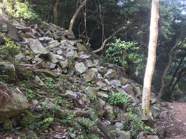
5. Why are there 7 terraced steps?
The Ancient terrace discovered in a thicket
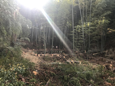
Although the island is part of a national park, Takegashima was neglected for many years and until 2015, was close to becoming an unruly, wild jungle. Cedar trees were planted in the midst of the supposedly beautiful bamboo forests that had survived since ancient times, and these plantations were cut down and scattered everywhere, leaving the island full of thickets and fallen trees that completely covered the ground.
Volunteers began to clear out the bamboo grove and they hauled away fallen trees and they also removed the roots of cedar trees. After five years of cleaning up around the bamboo grove, the bamboo grove of Takegashima started to come back into its former state of beauty.
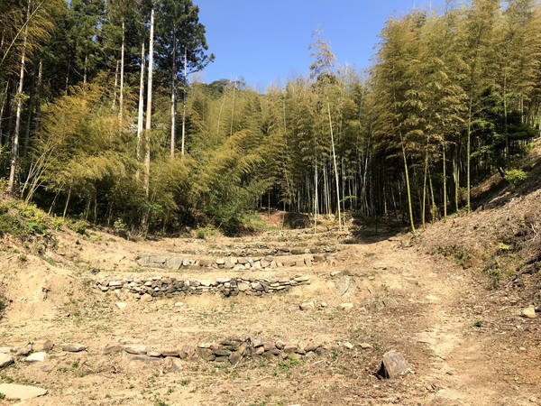
The seven terraced steps made of large stonesThe existence of a seven-stage terrace came to the fore during the maintenance project. It might be easier to understand them as terraced crop fields. In other words, seven terraced steps were built from the west side of the island facing eastward toward the bamboo grove in the center of the island.As we proceeded with the maintenance, the shape of the terrace became clearly visible. To the west of this terrace facing toward land, there is a mountain road that descends about 200 meters. The western shore beyond is called "Bishago Iso”. In ancient times, bridges were not constructed like today's bridges, so it is thought that people first used boats to reach Bishago Iso and then climbed the mountain path to reach the terrace.
According to local legend, during the poor pre warring period, the islanders planted crops in these terraced fields in order to secure food for themselves. This type of cultivation was possible because these naturally terraced grounds that had existed here before that time are appropriate as cropping fields.
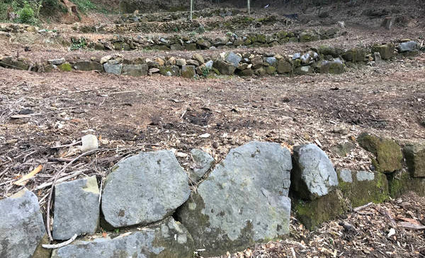
The seven terraced steps
were made with large stones.The terrace tiers were probably built in several different periods since the stones were stacked in such a way that cut and size of the terrace differed greatly from tier to tier. The stones that were used to build the third step from the bottom are large and so solidly built that only a stonecutter could cut through these stones. This is probably the oldest tier, and it is unlikely that it was made by islanders. The way the stones were cut and the arrows used suggest that they are quite old, so old that the terraces existed long before human habitation of the island.
During the autumnal equinox,
the sun shines from the East!Moreover, these seven steps of terraces are aligned east to west, so that when the sun rises from the Pacific Ocean side during the spring and autumnal equinoxes, the morning sun shines through the bamboo grove and onto the terraces. It is easy to take the terraced steps for granted since the uplifted rocks almost always run from East to West, but why was such a terrace built between boulders toward the center of the island? . Was the mountain path built so that visitors coming up from Bishago Iso along the coast would first reach this terrace? It seems to me that this terrace was built to lead people in pilgrimage to the bamboo forest and the sacred center of the island. What was the ancient purpose for which this terrace was built?
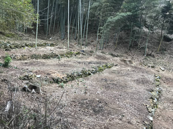
6. Was Takegashima a megalithic quarry?
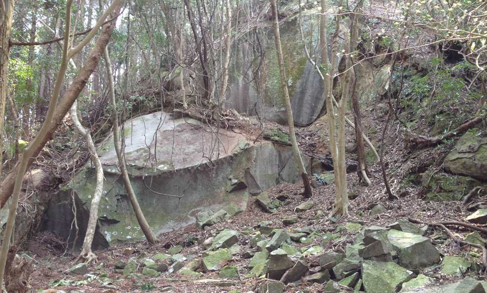
Ruins of where stones were cut at the quarry
Large arrow marks can be seen
at the corners of the megalithsThe largest megalith on the island is exposed at the beginning of the mountain path which goes through the seven terraces and is leading down to the Bishago rocky shore., The fact that the site was a large quarry can be understood from the large arrow marks that were left in the upper corners of the boulder. Large 8-10 cm wide arrows were used to cut the megaliths, and arrows 4-5 cm wide were used to cut the smaller stones. In terms of the size and shape of the arrow marks left behind, the large arrow marks are similar to the way stones were cut when Osaka Castle was built, i.e., from the time of Toyotomi Hideyoshi to the Muromachi period. The smaller arrow marks, however, appear to be too difficult to estimate the date .
The countless stone megaliths piled up
along the mountain roadThe area directly in front of and around the megaliths is filled with stones thought to have been cut from them. Stones of various sizes and shapes are scattered about, ranging from small pieces no more than 10 cm in size to large stones as large as 1 meter long. With an added note, the stones piled up on the sides of the entrance to the descent to the Bishago rocky shore. The stones are neatly piled up on the slope of the mountain path so that they do not collapse, forming a slope. When one climbs up the slope and removes the stones, one can tell that the stones have been artificially piled up, as there are many hollows below. There is no way to know why the stones were left piled up on the slope of the mountain path.
The fragments that still bear the marks of the arrows that cut the stonesWhere did the many huge stones cut off from the main source of rock go? Were they transported from Takegashima to Osaka Castle? Or were they used in some construction, as ordered by the shogun of a different era or a powerful local family? Were they used to form the terraced steps on the island or the rocky terrain around the bamboo grove? The whereabouts of the eliminated rocks on either side of the "Wall of Rock" are also unknown. Where were the boulders at the entrance to the terrace cut off and transported to?
7. How did the golden chicken get to Takegashima?
Marker of the Golden Cock in Ishio Shrine
in Tokushima PrefectureThere are several places in the Tokushima area that have long been said to have been visited or hidden by golden chickens. Ishio Shrine in Anabuki, whose deity is the giant stone itself, is an example of a shrine with a long tradition of the golden chicken folklore.
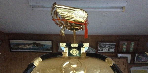
The golden chicken displayed
on top of the portable shrine at Takegashima ShrineThere are also legends associated with golden chickens in the vicinity of Takegashima. To the south of Takegashima, there is a small island that floats barely visibly in the sea. Futakojima is the smallest of them all, with the longest side measuring only 10 meters in diameter. Today, Futagojima is managed by a fishermen's association, but in ancient times, this island was of great importance.
Even on the other side of Shikoku, adjacent to Takegashima, a golden chicken is enshrined as a deity at the Kumano Shrine on the Toyo-cho side of Kochi Prefecture, south of the Tokushima side. It is said that the golden chicken, which shines as the Kumano Gongen of Ki-nachi, flew to Futagojima. The golden chicken has been enshrined as the deity at Kumano Shrine, which was built on a hill in Kouura, Toyo-cho, near Takegashima. Interestingly, according to legend, the Kumano Shrine has no torii gate because it has been built many times but then fell down. The torii gate is a symbol to ward off evil, but does it mean that the Gongen no Mikami itself has arrived so that there is no need for such a gate? Since then, the Kumano Shrine has remained a torii-free shrine to this day. What is important is the legend that a golden cock flew to the tiny Futakojima Island, which is only a few meters above sea level, less than 100 meters from Takegashima. Where there is no fire, there is no smoke.
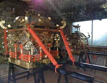
For some reason, a golden chicken was placed
on top of the beautiful mikoshi (portable shrine)Centuries, no, more than a thousand years have passed since then, on the day of the festival in May, the mikoshi, also called "abare mikoshi," is carried on the shoulders of young men and carried down the stairs from the Takegashima Shrine to the sea on the eastern shore, where the mikoshi is carried underwater. Of course, a golden chicken is placed at the top of the mikoshi. Why is the mikoshi carried into the sea? Why is there a legend of a golden chicken that flew to Futagojima, a small rocky island just beyond Takegashima? Why is the golden chicken-like object placed on top of the portable shrine carried by the Takegashima Underwater Mikoshi?
The worship hall of
the Takegashima ShrinePerhaps the golden cock really did visit Takegashima. This may have been the occasion for the Kumano Shrine to be erected, and on Takegashima, a rock formation was built on the eastern shore where the sun rises, and since the number three is considered a sacred number, a rock formation consisting of three rows of giant boulders was carefully built there. Is it really unreasonable to assume that earth was piled up in the center of the island to purify the island, and that ritual activities were conducted there? To protect the center of the island, bamboo groves were artificially created.
The sacred tree at the back
of the front shrine.Is the romanticism associated with the golden chicken really connected to Takegashima? We can’t stop thinking over the romance of Takegashima. And Kukai, Kobo-Daishi proves that it is not only mere romance but truce with sculptures carved by himself.